
Author: Alicia Wood, PWF Communications Coordinator
Long before individual ownership of divided acreage carved up the Hawaiian Islands, Hawaiians adhered to a moku-ahupua‘a form of land management. Joining us to discuss this system is Maui native Scott Fisher, Director of ʻAina (land) Stewardship with Hawaiʻi Land Trust (formerly Hawaiian Islands Land Trust). He also teaches a course at the University of Hawaiʻi Maui College called Tradition and Sustainability and has a passion for the land and history.
Why was the moku-ahupuaʻa system created?
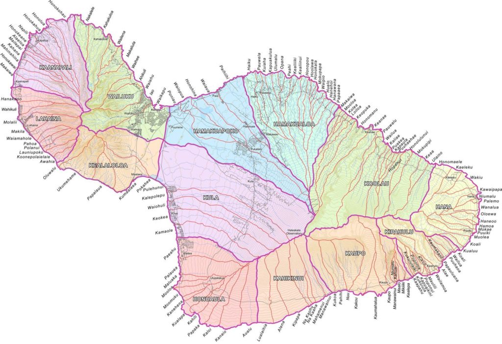
The very first Hawaiians are thought to have arrived all the way from the Marquesas Islands between 400 – 950 C.E., and were later conquered by Tahitians around 1300 C.E., combining cultures into the ancient native Hawaiian culture we are most familiar with today. Scott explains that, around the 15th century as people expanded to drier, more arid climates, there was concern about resources and the sustainability of their way of life. He tells of the legend of Chief Maʻilikūkahi of Oʻahu, who came up with a system of dividing land to address the overtaxing of resources or Tragedy of the Commons. This system divided the land from the peak/ridge-line of the mountain into the ocean in large tracts of land called moku. Within each moku are smaller divisions of land called ahupuaʻa. Moku and ahupuaʻa were based on available resources of the areas and ranged in size from 300 acres to 100,000 acres. Why was the land divided in this way specifically?
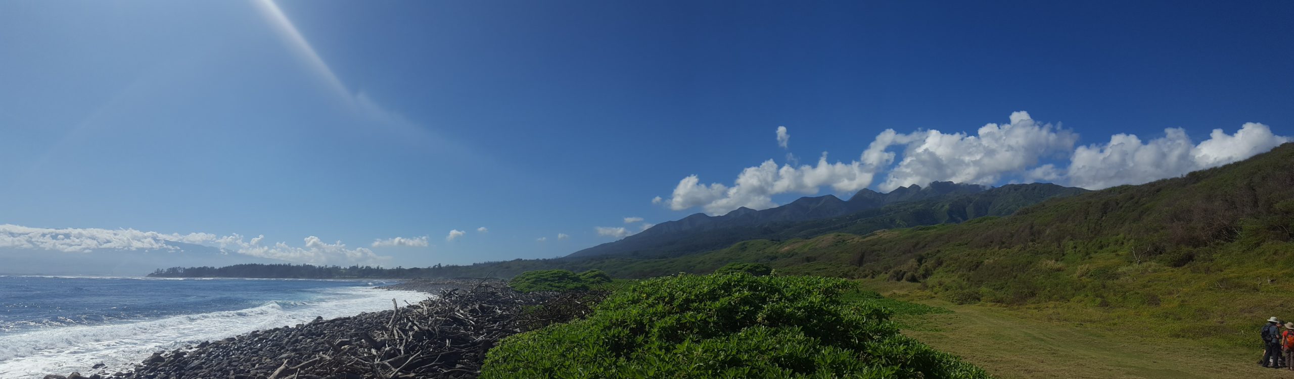
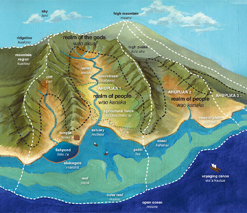
A common way to think of the health of the environment of Hawaiʻi is from mauka to makai (mountains to the ocean). While the ocean is obviously a separate ecosystem from the land, they are intrinsically linked. Freshwater brought via streams to the ocean can be beneficial for the near-shore environment. However, if the forests and land are not healthy, it can cause detrimental impacts. For example, if healthy forests degrade into eroded and barren land instead of healthy forests, too much sediment is washed away during rainfall and deposited into the ocean causing harm to coral reefs and all organisms that depend on them. This form of land management, that considered a holistic approach, proved successful and quickly spread to the other Hawaiian Islands, each their own kingdom at the time. In fact, mauka to makai remains in current use as a geographical barometer of overall environmental health in Hawaiʻi to this day.
How did an ahupuaʻa function?
Scott informs us that the overarching goal of the moku-ahupuaʻa system was to meet everyone’s needs for survival. Each person/family had their respective kuleana (duty) to provide for the community. If you were a fisher, you likely lived near the coast where you maintained fishing nets and harvested food from the ocean. If you were a farmer, you would have likely lived at slightly higher elevation near freshwater streams and farmed kalo (taro) and other crops. Each ahupuaʻa was managed by the konohiki, a chief of among the 12 existing ranks, who reported to a higher ranking aliʻi (ruler/governor). Their role was to make decisions for the community and ensure that all needs were met without overtaxing resources. Although almost every moku or ahupuaʻa was divided vertically from mountain to the ocean and beyond into the near-shore environment, specific sections were purposely left uninhabited. The wao akua — forest of the gods — was entered only to gather necessary supplies, such as trees or the feathers of forest birds. People did not typically live within these high elevation cloud forests. Villagers lived, farmed, fished and raised families in areas known as wao kanaka — forest/area of the people. These areas were the main hub of daily Hawaiian life and ranged from the coast upland to the base of the wao akua. In the moku-ahupuaʻa system, resources were shared within the community and everyone had a vested interest in working together to maintain the ecological integrity of the ahupuaʻa so it could continue to provide for their needs and ensure survival.
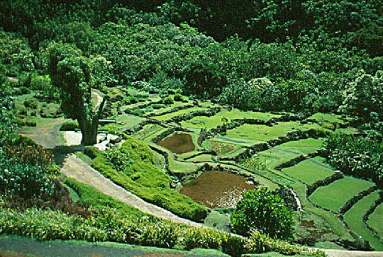
One interesting method noted by Scott highlights how the people and systems of this time worked together to protect precious resources and mitigate the sedimentation issue discussed previously using a combination of kalo farms and fishponds, a form of aquaculture. Kalo farming, which was typically conducted upland, generates a fair amount of sediment. To combat this excess sediment running into the ocean, water was filtered from one loʻi (terraced kalo patches) to the next and so on, capturing 90% of the sediment from loʻi to loʻi and eventually running down to the ahupuaʻa’s fishpond, or a retention pond if the ahupuaʻa did not have a fishpond. The practice of having a chief manage and distribute resources equitably as others executed individual specific roles resulted in a mutually beneficial and sustainable system.
Why did the moku-ahupuaʻa system come to an end?
The moku-ahupuaʻa system eventually came to an end due to a combination of demographic shifts and the transition to private ownership, Scott notes. Unfortunately, introduction to westerners also brought introduction to diseases such as smallpox, cholera, Hansen’s Disease (leprosy), etc., which decimated the Hawaiian population from an estimated 600,000 to 800,000 down to around 50,000 by the 1850s. As the population crumbled, so did the moku-ahupuaʻa system. In an effort to regain stability, King Kamehameha III initiated The Great Māhele in 1848, which divided the land into private parcels. One-third of the land was allocated to the mōʻī (monarch) Hawaiian crown lands and another third was allocated among the aliʻi (ruler/govenernor) and konohiki (Chief Land Steward of an ahupua‘a). The remaining one-third was given to the makaʻāinana (common people). This was meant to protect the land from foreign interests, however, the new law required land claims to be filed within two years. Due to several reasons, likely including the fact that the Hawaiian language had been in written form a mere two decades, many Hawaiians made no claim and much of the land ended up in the hands of foreign interests regardless.
Although the moku-ahupuaʻa system is no longer employed, there are remnants of its existence to this day; small areas of farming where techniques largely remain unchanged, kalo farmers sharing water resources for the benefit of all and large tracts of land with a single owner, mostly ranches, that still retain the shape of the former ahupuaʻa.
What are the meanings behind the names of various moku or ahupuaʻa?
Thankfully, the names and borders of moku and ahupuaʻa were recorded and are still known to this day. Although Scott informs us that, while these names can give us more information about the place, it is often very difficult to know the true ‘hidden’ name behind each one. Not only was there no written Hawaiian language when these areas were named, many Hawaiian words also have multiple meanings. Scott shares with us three different stories explaining, for instance, how Maui’s Waiheʻe got its name. First, know that wai means fresh water and heʻe has a number of meanings, including but not limited to octopus, slip, slide and flee. One story goes that there was a certain algae that grew in the streams of the area that was very slippery. Another tells of two brothers, one of whom threw a pot of boiling water (wai) containing heʻe (octopus) at the other during a fight. Yet another describes a certain ʻline in the sand’ where, if you were fleeing an enemy or escaping punishment, crossing that line kept you safe. If you are interested in learning more about an ahupuaʻa you reside in or have visited, I recommend visiting wehewehe.org and looking up the words that make up the name and seeing what you may glean from that information. The ahupuaʻa tract that I have called home for almost a decade is Waiohuli. As we know, wai is fresh water; the letter “o” typically represents the preposition “of” and huli has many meanings but most commonly refers to change or rotation/turning over and over. As that the area is prone powerful streams that appear only when there is heavy rain, the name Waiohuli may refer to the churning of these occasional flood-streams. However, huli can also mean seek, investigation or scholarship. Maybe there was a great konohiki who studied the waters of the area and the ahupuaʻa was so named in honor? Although you may not find a definitive answer, you will certainly learn something and probably have a lot of fun doing it! I know I have!
Where can I find further reading?
The moku-ahupuaʻa system was very successful in its day and supported a very large population for that time. In learning about it, we can question our own land management systems and how they could be improved to be more sustainable. If you would like to learn more about the moku-ahupua’a system and Hawaiian history, Scott highly recommends the engaging book A Shark Going Inland is My Chief, written by UH Mānoa archeology professor Patrick Vinton Kirch. You can also stop by Waiheʻe Coastal Dunes (Maui) and other areas in Hawaiʻi through Hawaiʻi Land Trust and volunteer or go on a Talk Story Hike and learn more about the rich history and culture of the area and Hawaiʻi. Stay tuned for our next Voices of Maui Nui blog on the exquisite storytelling convention known as hula.